- You are here
- Home
- Guide to Africa
-
- Tanzania Guide
- Tanzania National Parks and Game Reserves
- Mount Kilimanjaro National Park
- Climbing Mount Kilimanjaro
- Climbing Mount Kilimanjaro via Umbwe Route
Climbing Mount Kilimanjaro via Umbwe Route
Parent page
On this page
Introduction
The Umbwe Route up Kilimanjaro is the most spectacular and direct way to reach Uhuru Peak.
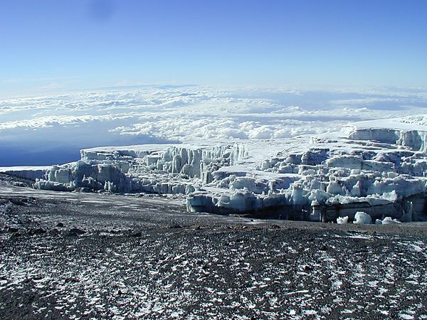
This route became famous when it was featured in the dramatic IMAX film "Kilimanjaro - To the Roof of Africa". On the Umbwe, you pass through strange landscapes, as you climb through five climate zones ranging from rainforest to the summits glaciers. The route follows a forested ridge to the moorlands, then traverses below the southern icefields to reach the Machame Route, which you follow to the summit.
This steep, tough, and in places slightly exposed trek is suitable for a fit individual used to walking in mountain areas. Because of the routes' steepness, it is seldom used, and trekking poles are useful on the steep, slippery slopes in the rainforest.
All your equipment and supplies are carried by porters and a cook prepares all your meals. Unlike the Marangu Route where you sleep in huts, on the Umbwe Route you sleep in tents and the porters will generally pitch your tent for you.
Day 1
Moshi/Arusha to Umbwe Gate to Umbwe Camp
An hour drive from Moshi/Arusha to Umbwe Village where your guides and porters pack your equipment and supplies. You start your ascent at the small Umbwe Gate just above the village and follow a gentle winding vehicle track for an hour to a signboard that announces the small steep Umbwe trail. You now climb up for several hours through a dense forest of rubber trees and giant fig trees. In places, you must scamper up steep sections of roots and rock. The Umbwe Camp is in the forest, and there are some caves nearby.
Elevation(m): 1915m/1387m to 1800m to 2800m - Distance: 8km - Hiking Time: 5-7 hours - Habitat: Montane Forest
Day 2
Umbwe Camp to Barranco Camp
Upon leaving camp you will climb steeply through thinning forest glades to Giant Erica, Heather, and drier air. You continue up a ridge that drops steeply on both sides, and hopefully, the clouds will part to reward you with a view of Uhuru Peak looming overhead. You then enter a zone of giant groundsels (Seneci Kilimanjari) that seem to guard the heights, and this garden is one of Kilimanjaro’s special treasures. You spend the night at Barranco Camp
Elevation(m): 2800m to 3900m - Distance: 8km - Hiking Time: 4-5 hours - Habitat: Semi-Desert
Day 3
Barranco Camp to Karanga Camp
Start the day going up a steep ridge to the great Barranco Wall, which although imposing is easier than it looks. Topping out just below the Heim Glacier, you can now appreciate just how beautiful Kilimanjaro really is. With Kibo’s glaciers soaring overhead, you descend into the lush Karanga Valley to the Karanga Valley campsite. From the camp, you can look east and see the jagged peaks of Mawenzi jutting into the African sky. You arrive at camp early and the purpose of this short day is for ease of acclimatization.
Elevation(m): 3900m to 4200m - Distance: 7km - Hiking Time: 4 hours - Habitat: Alpine Desert
Day 4
Karanga Camp to Barafu Camp
In the morning, you hike east over intervening ridges and valleys to join the Mweka Route, which will be your descent route. Turn toward the mountain and hike up the ridge through sparse landscape for another hour to the Barafu Hut. The famous snows of Kilimanjaro are far above Barafu Camp near the summit of the mountain. Your camp is on a narrow, stony, wind-swept ridge, so make sure that you familiarize yourself with the terrain before dark to avoid any accidents. Prepare your equipment and warm clothing for your summit climb, and drink a lot of fluids.
Elevation(m): 4200m to 4550m - Distance: 13km - Hiking Time: 8 hours - Habitat: Alpine Desert
Day 5
Summit Day! Barafu Camp to Uhuru Peak to Mweka Camp
You will rise about midday and start your 6-hour climb northwest up through heavy scree between the Rebmann and Ratzel glaciers to Stella Point on the crater rim. This is the most challenging part of the route for most climbers. At Stella Point you stop for a short rest and a chance to see the sunrise, do not stop here too long, as it will be extremely difficult to start again due to cold and fatigue. Depending on the season and recent storms, you may encounter snow on your remaining hike along the rim to Uhuru Peak. A short stop at the summit with photo opportunities and then you start your 3-hour descent from the summit back to Barafu Camp, fro here you hike down a rock and scree path into the moorland and eventually into the forest to Mweka Camp . This camp is in the upper forest, so you can expect mist or rain in the late afternoon. Provided it is available the camp office sells drinking water, soft drinks, chocolates, and beer!
Elevation(m): 4550m to 5895m, descend 3100m - Distance: 7km up, 23km down - Hiking Time: 8 hours up, 7-8 hours down - Habitat: Scree and seasonal snow
Day 6
Mweka Camp to Mweka Gate to Moshi/Arusha
A short, scenic 3-hour hike back to the park gate to the end of your climb. Here successful climbers will receive a certificate. Generally this is the last time you will see your guides, cooks, and porters, so if you were happy with their hard work please remember to tip them once you and all your gear has reached the gate. Take note that occasionally during the raining season the road to Mweka Gate is not passible for vehicles, so you may have to continue down to the Mweka Village which is another 3 km away (about 1 hour hike) to meet up with your transport back to Moshi/Arusha.
Elevation(m): 3100m -to 1980m to 890m/1387m Distance: 15down - Hiking Time: 3 hours - Habitat: Forest
