- You are here
- Home
- Guide to Africa
-
- Tanzania Guide
- Tanzania National Parks and Game Reserves
- Mount Kilimanjaro National Park
- Climbing Mount Kilimanjaro
- Climbing Mount Kilimanjaro via Machame Route
Climbing Mount Kilimanjaro via Machame Route
Parent page
On this page
Introduction
The Machame Route is one of the most scenic routes on Kilimanjaro that allows you to experience the southwest and south sides of the mountain, since you ascend one way and descend down another route.
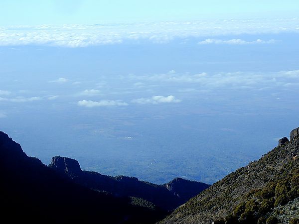
With the Machame/South Circuit route, you will circle halfway around the mountain with great views from all angles. Mount Meru is often seen on the route, providing spectacular sunset views and after the third day you are often above the clouds, on a clear day you get a wonderful views of the plains for Africa below. Just don't forget to take the time to look behind you. Remember there is no rush and the slower you go the more chance you have of your body dealing with the altitude.
This route is approximately 40km versus 20km on the Marangu route. Climbers descend down the Mweka Trail and stay at the Mweka camp the final night on the mountain.
Generally the Machame Route up and down is climbed in 6 days (5 nights) but to increase your chances of making it to the summit you should consider adding an extra day for acclimatisation.All your equipment and supplies are carried by porters and a cook prepares all your meals. On the Machame Route you sleep in tents (tents are generally included in the price), and the porters will pitch your tent for you.
Meals are served in a dinner tent or on blanket outside. This makes the Machame, which is referred to as the "Whiskey Route", better suited to more adventurous hikers, and it is also rewards you with better views than the Marangu Route.
The sanitation facilities are very basic, mainly long drop toilets, which can sometimes be rather smelly. As a general rules the last group to leave a camp should that a bucket a water to thrown round the long drop and that all rubbish has been taken away. Sadly this does not always happen.
Advantages:
Relatively low cost
A very scenic Kilimanjaro route
Higher success rate than Marangu Route


Day 1
The drive from Arusha to the Mount Kilimanjaro National Park Gate takes about one and half hours. The journey passes through the village of Machame which is located on the lower slopes of the mountain. You will register at the park gate and walk through a beautiful rain forest on a winding trail up a ridge. The trail can be muddy and slippery lower down. The hiking time is 5-7 hours and distance is about 18kms. Elevation (m): 1830m to 3100m
Day 2
You leave the rain forest behind and continue on an ascending path, crossing the valley walking along a steep rocky ridge, covered with heather, until the ridge ends. The route turns west onto a river gorge. You overnight at the Shira campsite. The hiking time is 4-6 hours and distance is about 9kms. Elevation: 3100m to 3840m
Day 3
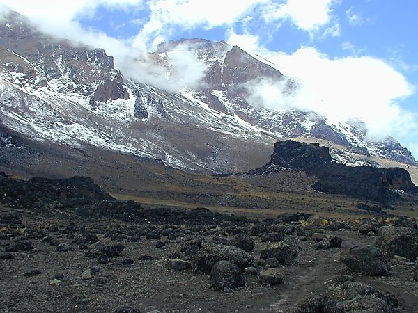
From the camp you to the east, up a ridge, passing the junction towards the peak of Kibo. The direction changes to the South East towards the Lava Tower, called the "Shark's Tooth." Shortly after the tower, the route takes you the Arrow Glacier (altitude 4,876m). From here you descend to Barranco Hut (altitude 3,860m). Here we rest, enjoy dinner, and overnight. Although you end the day at the same elevation as when you started, this day is very important for acclimatization. The hiking time is 5-7 hours and distance is about 15kms. Elevation: 3840m to 4630m to 3860m
Day 4
Leaving Barranco Camp you continue on a steep ridge up the Barranco Wall, through the Karanga Valley, the junction which connects with the Mweka Trail. We continue up to the Barafu Hut. You have completed the South Circuit, which offers views of the summit from many different angles. The two peaks of Mawenzi and Kibo are to be seen from this position. The hiking time is 8 hours and distance is about 13kms. Elevation: 3860m to 4600m
Day 5
Summit Day
Start very early in the morning (between midnight to 2am) to the summit between the Rebmann and Ratzel glaciers. You head in a northwesterly direction and ascend through heavy scree towards Stella Point on the crater rim. This is the most mentally and physically challenging portion of the trek. At Stella Point (5685m), you will stop for a short rest and will be rewarded with the most magnificent sunrise you are ever likely to see (weather permitting). When you stop at Stella point, there is a huge temptation to feel that you can not go on, but from Stella Point it is only 1-hour to the summit and you have done the hardest bit. (do not give up now) . At Uhuru Peak, you have reached the highest point on Mount Kilimanjaro and the continent of Africa. You will be spend a few minutes at the summit, to absorb the views and take photographs.
From the summit, you start your descent continuing straight down, the first part of the descent can be tough going, due to the loose gravel and steep slope, plus your energy levels are low. That evening you stop Mweka Hut camp site which is situated in the upper forest and mist or rain can be expected in the late afternoon. This is a very long challenging day.
The hiking time is 6- 8 hours ascent / 7-8 hours descent distance: 7km ascent / 23km descent. Elevation: 4600m to 5895m (and down to 3100m)
Day 6
Continue the descent down to the Mweka Park Gate to receive your summit certificate. At lower elevations, it can be wet and muddy. Shorts and t-shirts will probably be plenty to wear (keep rain gear and warmer clothing handy). From the gate, continue another hour to Mweka Village. Here you can have a well earned drink and meet up with the guides, porters, and cooks, who will be waiting for their tips. (See Kilimanjaro Tipping Etiquette/Recommendations)
The hiking time is 4-4 hours - distance: 15km - Elevation: 3100m to 1830m
