Zimbabwe Guide
Parent page
Introduction
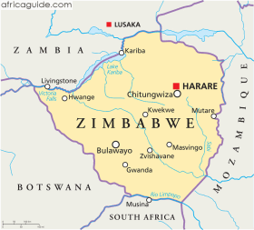
Zimbabwe is a landlocked country in south-central Africa. It lies between the Zambezi River in the North and the Limpopo River to the south. The country has land borders with Mozambique to the north and east, South Africa to the South, Botswana to the southwest and Zambia to the northwest and north.
Most of Zimbabwe is rolling plateau, with over 75% of it lying between 610m (2000 ft) and 1,525m (5,000 ft) above sea level, and almost all of it over 305m (1,000 ft).
The area of high plateau, know as the high Veld, is some 400 miles long by 50 miles wide, and stretches northeast to southwest at 1,220m (4,000 ft) to 1,676m (5,500ft) This culminates in the northeast in the Udizi and Inyanga mountains, reaching the country's highest point at Mt. Inyangani at 2,596m (8,517 ft). The middle veld is a plateau ranging from 610m (2,000 ft) to 1,220 m (4,000 ft) high. Below 610m (2,000ft) are areas making up the Low Veld, wide and sandy plains in the basins of the Zambezi and the Limpopo.
The steep mountain ranges cut Zimbabwe off from the eastern plains that border the India Ocean. The High Veld is a central ridge forming the country's watershed, with stream flowing southeast to the Limpopo and Sabi rivers and northwest into the Zambezi. Deep river valleys cut the Middle Veld. Only the larger of the many rivers have an all-year-round flow of water. Most of rivers have falls and rapids.

