- You are here
- Home
- Guide to Africa
-
- Malawi Travel Guide
- Malawi Regions and Towns
- Zomba Plateau
Zomba Plateau
Parent page
On this page
Introduction
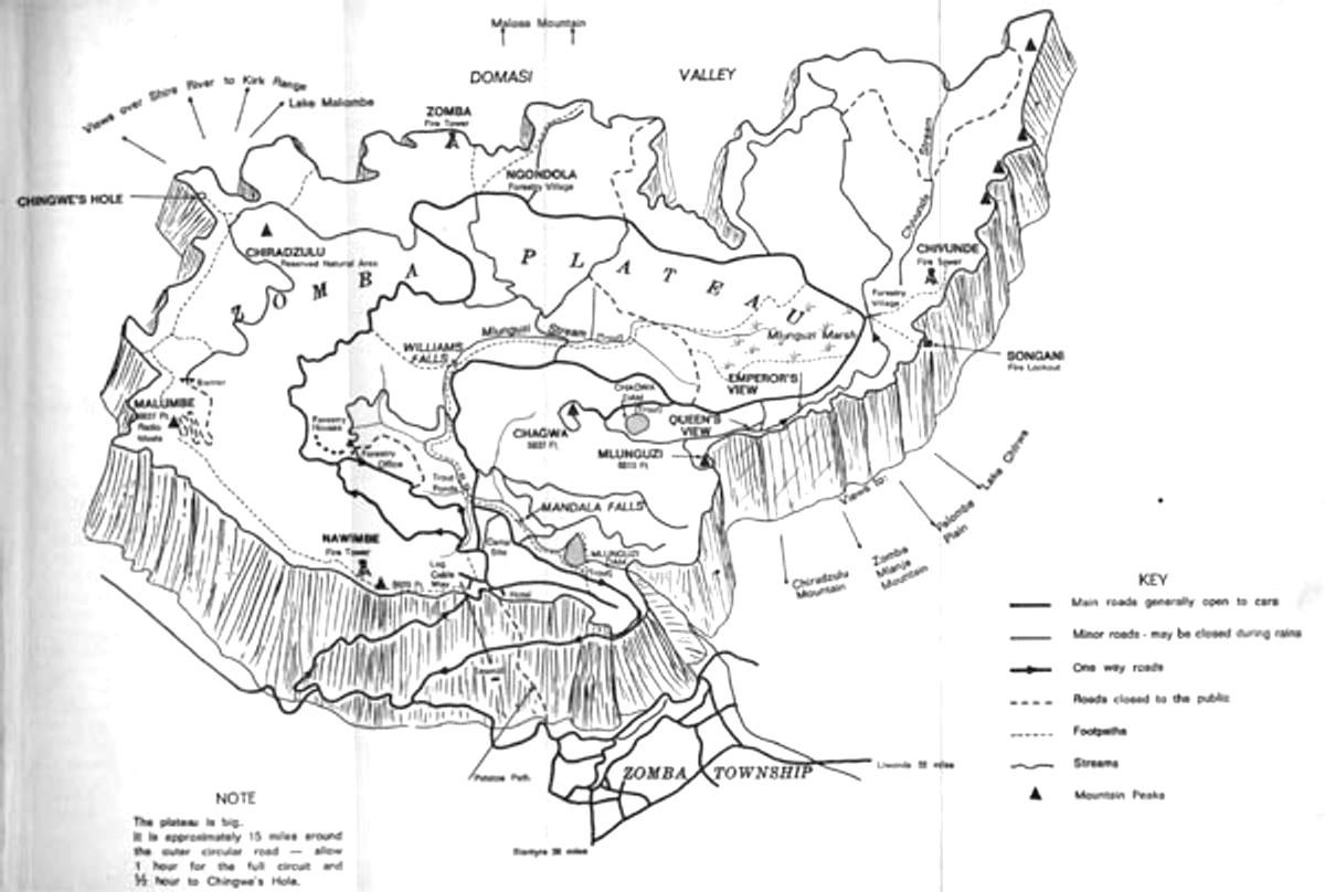
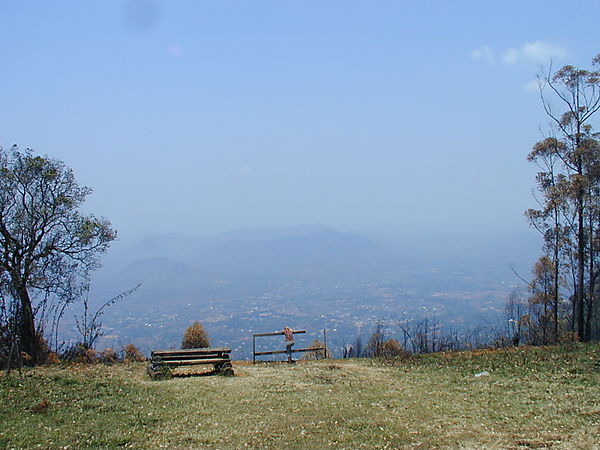
Zomba Plateau MapZomba plateau offers a pleasant variety of walks through forest, beside streams and across open grassland. Many of the walks are fairly short but there are opportunities for longer walks if time and energy permit. Due to the higher altitude the plateau often feels pleasantly cool compared to other parts of the country.
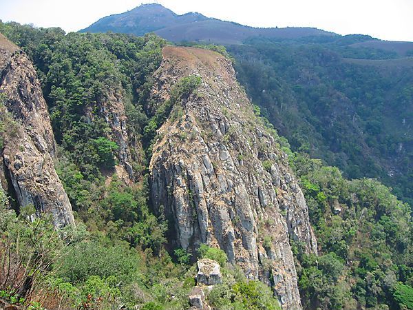
The plateau has been formed by an intrusion of molten rock into the overlying metamorphic rock. Over time, the softer metamorphic rock has been eroded from over and around the intrusion and this has left the harder igneous rocks, which formed the plateau, raised above the surrounding plain.
Most of the plateau is under active management by the Department of Forestry. Thankfully, they have left some of the natural flora along the streams and under Chiradzulu peak. A variety of soft woods are being grown on the plateau, the main ones being Mexican Pine (Pinus patula) and Cypress (Cupressus luscitanica). These are ready to harvest after 25 to 30 years. Mulanje Cedar (Widdringtonia nodiflora) is also being planted but this is a much slower growing hardwood, taking over 60 years before being harvested.
A variety of birds are seen on the plateau. The most common bird is the white necked raven which soon becomes a spectator at any picnic. The croaking call often heard while walking is likely to belong to the green lourie which is sometimes seen as a larger bird moving about in the branches of a tree but is most easily seen when flying as it has vivid red underwings. Larger animals are sometimes seen; baboon and bushbuck being the most common.
Be aware: Whilst walking in long grass around the Nawimbe Fire Tower we the two founders of Africa Guide found ourselves surrounded by a large troop of baboons. Cautiously exiting via the direction of least baboons while giving them no eye contact got us outside the main group at which point the larger males charged putting on a show of strength urging us to quicken our pace which quickly became a full speed sprint. They gave chase for about 20 yards and then stopped as expected.
Keep a good lookout and wear a pair of trainers whilst walking in this area, trainers won't help you outrun baboons, but at least you won't be last in your group

The main access to the plateau is well signposted from the centre of Zomba Town. This is a tarred road to Kuchawe Inn. It is one way from just beyond Khola forestry village to where it joins the other roads near Kuchawe Inn. Before the down road was built in 1968 movement of cars was limited on this stretch so that cars were only allowed up between the hour and quarter past, and down between the half hour and quarter to.
The down road is an unsurfaced road which becomes fairly stony if not maintained. It is one way from shortly after the road goes off to Mulunguzi dam.
There is a little used road which winds its way up from Old Naisi. Go straight across the junction at the top of Old Naisi road and right at the T junction shortly afterwards. The road eventually comes on to the map below Makawa Spur. The basic surface of the road is usually not too bad but it becomes very overgrown with grass which makes it difficult to see where to go at times.
Walkers desiring a different approach can drive out to Songani, north of Zomba, and take the road signposted to Domasi CCAP Mission. The road is in the process of being upgraded and should be passible to cars with reasonable ground clearance. It goes up in to Domasi valley and from there, there are a number of paths leading up on to the plateau and some also lead up on to Malosa mountain but these tend to be less well defined.
The road running south from junction 13 at the base of Mlumbe can be rough for private cars at times. Most of the other roads are in reasonable repair, though this can vary with the time of year and activities of the Forestry Department.
Regrettably, cars are occasionally broken into, so do not leave items visible in your car.
Mulunguzi Dam to the Trout Farm past Mandala Falls is a gentle pleasant walk through original forest beside the stream, (35 minutes).
As the water in the Mulunguzi stream and dam form the water supply for Zomba, swimming is only permitted in the Chivunde stream.
Part of this walk forms the Mulunguzi Nature Trail.
The Trout Farm to Williams Falls. A gentle, fairly easy walk through original forest beside the stream, (35 minutes).
Mulunguzi Dam to Chagwa Dam. A gentle climb from the dam wall up through planted forest to Chagwa Dam, (45 minutes).
Emperor's View to Songani Lookout. A gentle walk through planted forest on a track, (30 minutes).
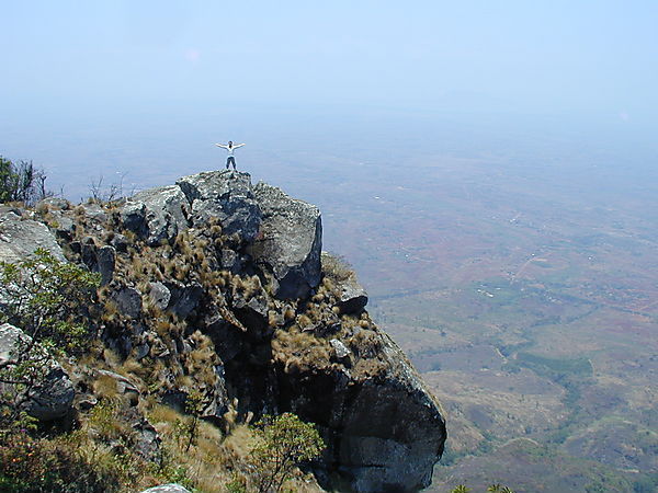
Songani Look out to Sphinx and Mbuli. An easy walk to Sphinx (30 minutes), slightly more strenous to Mbuli (+ 45 minutes). There are good views looking out towards Lake Chilwa. The path to Mbuli is faint and is near the outer lip of the plateau, not on the obvious firebreak further in.
Chivunde Village to Chivunde Falls. A moderate walk in an attractive valley with views towards the Chikala hills. Take the path which leaves the road a short distance below the village. This rejoins the road where it crosses the stream at the watersplash. Cross the stream and go down the road for about half a kilometre. Take the signposted path to the left. After passing through the trees, the path crosses some rock slabs and then drops fairly steeply. A faint path which leads to the falls goes off to the left near the bottom of the slope. The main path rejoins the road from the watersplash about 50 m below the falls. This offers an alternative route back, though at times it may be a bit overgrown, (45 minutes).
Kuchawe Inn to Nawimbe Fire Tower and onto Mlumbe Radio Masts. A moderate climb up to Nawimbe (35 minutes) and then a pleasant ridge walk to Mlumbe, (+ 70 minutes).
Forestry Offices to Chiradzulu Peak. A good walk and climb through planted and natural forest. The marked view point gives one of the best views of the plateau basin. Take the road north from the offices and turn left on to the first definite path, just before a bridge (90 minutes).
The Potato Path from just above Zomba to Kuchawe Inn. A good climb. This is the first part of a path which goes right across the plateau to Domasi valley and has been used for a long time to bring produce to the market in Zomba. Follow the path from the signpost on the first bend in the road after leaving the buildings of Zomba, (45 minutes).


Mulunguzi Dam
Trout Farm (especially of interest to children)
William's Falls
Chagwa Dam
Queen's View
Emperor's View
Songani Lookout
Chingwe's Hole
Sunbird Ku Chawe Inn stands overlooking the Zomba Plateau. having 37 rooms which are en suite, air-conditioned, have digital satellite television, international direct dialing, Wi-Fi internet, email facilities.

Zomba Forest Lodge is a unique small guesthouse nestled amongst the forests of Zomba Plateau.
There are two campsites on the plateau.
The main campsite is the one near the Ku Chawe Inn. This is a well organised campsite with running water and hot showers are usually available. It is often busy, especially on holiday weekends.
The Chitinii campsite on the west of the plateau is much less used and is more basic.There is a latrine provided and water comes from the nearby stream. It is a good site for those who wish to get away from everything.
There are also several small lodges and B&B's in Zomba Town.
