Benin Guide
Parent page
Introduction
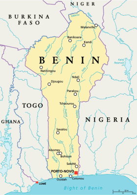
Benin is situated in West Africa on the northern coast of the Gulf of Guinea. It has land borders to the north by Niger, on the west by Togo, and on the northwest by Burkina Faso.
The coast has no natural harbors, river mouths or islands, due to sandbanks making access difficult. Behind the coastline is a network of lagoons, from that of Grand Popo on the Togo border (navigable at all seasons) and joined to Lake Aheme, to that of Porto-Novo on the east, in which flows Benin's longest river, the Oueme, navigable for some 125 miles of its total of 285 miles. Beside Oueme, the only other major river in the south is Couffo, which flows into Lake Aheme. The Mono, serving from Parahoue to Grand Pope, has the boundary with Togo and is navigable for 50 miles but subject to torrential floods in the rainy season.
Benin's northern rivers, the Mekrou, Alibory and Sota, which are tributaries of the Niger, and the Pandjari, a tributary of the Volta, are torrential and broken by rocks. North of the narrow belt of coastal sand is a region of lateritic clay, the main oil palm area, intersected by a marshy depression between Allada and Abomey that stretches east to the Nigerian frontier. North of the hills of Dassa, the height ranges from 200 to 500 feet, broken only by the Atakora Mountains (1,500 - 2,400 ft), stretching in a southwesterly direction into Togo.

